- Home
- Products
- Microwave Remote Sensing Instruments
- Humidity And Temperature PROfilers
Humidity And Temperature PROfilers
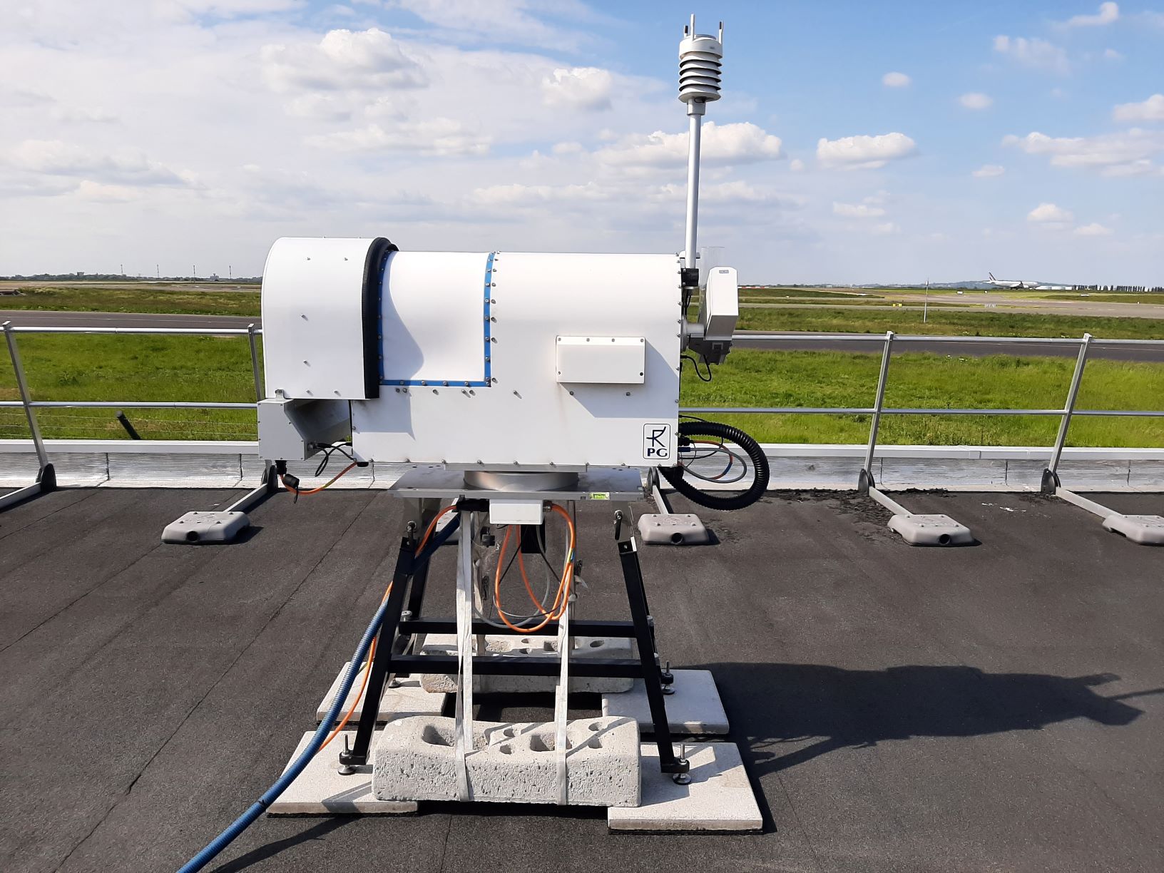
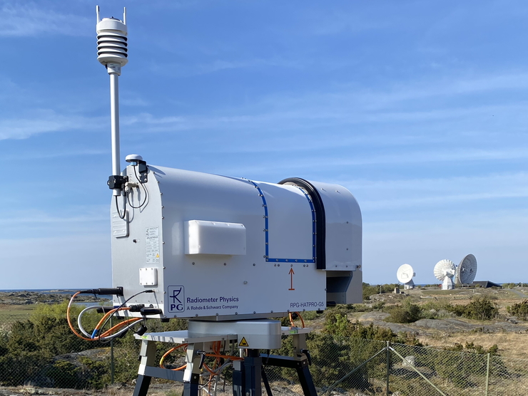
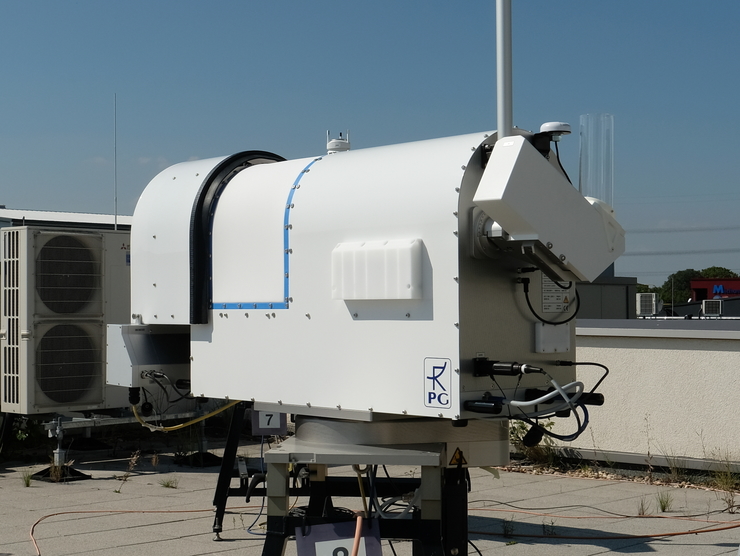
RPG's profiling radiometers are mainly used to derive vertical profiles of atmospheric temperature and humidity (RPG-HATPRO). The infrared radiometer extension allows to cloud base height and ice cloud detection.The radiometer series covers high-resolution temperature profiling of the boundary layer and low-humidity applications. All models of the series provide accurate total amounts of atmospheric water vapor and cloud liquid cloud. RPG radiometers are stand-alone systems for automated weather-station use under nearly all environmental conditions. A variety of retrieval algorithms (custom designed and global standard algorithms) can be selected.
Applications:
Meteorological observations, Numerical Weather Prediction (NWP), forecasting, now-casting, climate monitoring, aviation meteorology, astronomy, geodesy.
Frequencies:
Two bands, 22-31 GHz (7 channel filter bank humidity profiler and LWP radiometer) and 51-58 GHz (7 channel filter bank temperature profiler)
Retrieved data types:
- vertical profiles of atmospheric temperature
- vertical profile of atmospheric humidty (relative and absolute humidity)
- Liquid Water Path (LWP)
- Integrated Water Vapor (IWV)
- wet delay
- dry delay
- stability indices
This system is very similar to the RPG-LWP liquid water path (two channel) radiometer: Only the receiver systems vary, housing and additional sensors are basically the same.
Models:
Different model types of profiling radiometers are available.
Model | Frequencies | Applications | |
---|---|---|---|
HATPRO | 22.24 – 31.4 GHz, 51.0 – 58.0 GHz | Humidity + temperature profiles (high precision in boundary layer), clouds, IWV, LWP, stability |
|
LHATPRO | 51.0 – 58.0 GHz, 183.31 GHz (6 DSB-channels to ±7.5 GHz) | Like HATPRO, but for Low-humidity (high altitudes, cold environments, PWV < 3 mm) | |
TEMPRO | 51.0 – 58.0 GHz | Temperature profiles, Boundary layer temperature profiling | |
HUMPRO | 22.24 – 31.4 GHz | Humidity profiles, clouds, IWV, LWP | |
LHUMPRO | 183.31 GHz (6 DSB-channels up to ±7.5 GHz) | Low-Humidity high-precision profiles (clouds: limited accuracy) |
Parameter | Specification |
---|---|
Humidity profile performance (zenith and along track) | Vertical resolution: 200 m (range 0-2000 m) 400 m (range 2000-5000 m) 800 m (range 5000-10000 m) Accuracy: 0.3 g/m3 maximum bias typical (abs. humidity) 0.1 g/m3 RMS typical (absolute hum.) 5% RMS (rel. humidity) |
Temperature profile performance (zenith and along track) | Vertical resolution: BL-Mode: 30 m (range 0-1200 m) Z-Mode: 200 m (range 1200-5000 m) 400 m (range 5000-10000 m) Accuracy: 0.25 K RMS (range 0-500 m) 0.50 K RMS (range 500-1200 m) 0.75 K RMS (range 1200-4000 m) 1.00 K RMS (range 4000-10000 m) |
Liquid water profile performance (only with IR radiometer option) | Vertical resolution: Accuracy: cloud base height: 50 m (range 0-300 m) 100 m (range 300-1000 m) 200 m (range 1000-3000 m) 400 m (range 3000-5000 m) 600 m (range5000-10000 m) density: 0.03 g/m3 RMS Threshold: 50 g/m2 LWP Only single layer clouds are modelled |
IR radiometer option | 9.6-11.5 µm band, accuracy 1 K, noise: 0.2 K RMS |
LWP | Accuracy: ± 20 g/m2, Noise: 2 g/m2 RMS |
IWV | Accuracy: ± 0.2 kg/m2 RMS, Noise: 0.05 kg/m2 RMS |
Full sky IWV and LWP maps (only with azimuth positioner) | 350 points in 6 minutes rapid scanning |
Satellite tracking mode (only with azimuth positioner option) | Determines wet/dry delay, atmospheric attenuation and humidity profiles along line of sight for all visible GPS / Galileo satellites in a single scan (2 minutes) scanning with RINEX navigation file or direct GPS vector reading from GPS clock |
Channel centre frequencies | K-Band: 22.24 GHz, 23.04 GHz, 23.84 GHz, 25.44 GHz, 26.24 GHz, 27.84 GHz, 31.4 GHz V-Band: 51.26 GHz, 52.28 GHz, 53.86 GHz, 54.94 GHz, 56.66 GHz, 57.3 GHz, 58.0 GHz |
Channel bandwidth | 2000 MHz @ 58.0 GHz, 1000 MHz @ 57.3 GHz, 600 MHz @ 56.66 GHz, 230 MHz @ all other |
System noise temperatures | <400 K typical for 22.2 – 31.4 GHz profiler <600 K typical for 51.4 – 58.0 GHz profiler |
Radiometric resolution | K-Band: 0.10 K RMS, |
Absolute brightness temperature accuracy | 0.5 K |
Radiometric range | 0-800 K |
Absolute calibration | with internal ambient & external cold load |
Internal calibration | gain: with internal noise standard gain + system noise: ambient temperature target + noise standard abs. cal. of humidity profiler: sky tipping calibration |
Receiver and antenna thermal stabilization | Stability better than 0.03 K over full operating temperature range |
Gain nonlinearity error correction | Automatic, four point method |
Brightness calculation | based on exact Planck radiation law |
Integration time | ≥ 0.4 seconds for each channel, user selectable |
Sampling rate for profiles | ≥ 1 sec, user selectable |
Rain / fog mitigation system | Highly efficient blower system (130 Watts), hydrophobic coated microwave transparent window, 1.8 kW heater module preventing formation of dew under fog conditions |
Environmental Sensors | On a 1-meter mast attached to the radiometer:
|
Data interface / rate | Ethernet (TCP/IP) |
Instrument control (external PC) | Windows™ System with Ethernet interface |
Instrument control (internal) | Embedded PC, controls all internal calibrations, data acquisition, data file backup on 10 GB flash memory, control of azimuth positioner, communication with host, can run measurements independently from host PC |
Housekeeping | all system parameters, calibration history documentation |
Retrieval algorithms | neural network, linear /nonlinear regression algorithms |
Optical resolution | HPBW (frequency dependent): 3.0° - 4.2° for water vapour, 1.8° - 2.2° for temperature profiler |
Side-lobe level | <-30dBc |
Pointing range / resolution | Elevation: 0° to 180° (0.15° steps), full s/w control |
Pointing speed | 45°/sec (elevation), 40°/sec (azimuth, optional) |
Operating temperature range | -40°C to +45°C |
Power consumption | <120 Watts average, 350 Watts peak for warming-up (without dew blower heater), blower: 130 Watts max. |
Lightning protection | Power line: circuit breakers Data line: Fibre optics cable (max. length: 1400 m) |
Input voltage | 90-230 V AC, 50 to 60 Hz |
Weight | 60 kg (without dew blower) |
Dimensions | 63 × 36 × 90cm3 |
Weather station | Lufft WS600-UMB |
- Network capability through Ethernet Interface
- Optical resolution: HPBW (frequency dependent): 3.0°-4.2° for water vapor, 1.8°-2.2° for temperature profiler.
- Radiometric resolution: K-Band: 0.10 K RMS, V-Band: 0.15 K (at 1 sec integration time).
- High repetition rate: filter bank receiver produces one atmospheric profile per second
- Absolute system stability: 0.5 K
- Receiver and antenna thermal stabilization: < 0.02 K
- Operating temperature range: –40°C to +45°C
- Automatic rain-mitigation system: hydrophobic coating and strong blower for rain, heater module with 1.8 kW preventing formation of dew and fog condensation on radome
- Integrated PC on-board
- Comprehensive operating software included (free updates)
- Full internal retrieval algorithm, retrieval data and raw data output
- GPS clock and receiver
- Additional external meteorological sensors: barometric pressure, humidity, temperature, wind (direction and speed), rain rate
- IR-radiometer option for cloud base height detection and ice cloud detection
- Azimuth positioner option for full sky scanning (350 samples in less than 6 minutes)
- North-alignment by software feature (sun-tracking plus GPS, only with azimith positioner)
- Fiber-optics data cable to connect radiometer to controlling host PC (maximum length 1600 m)
- Customized retrieval software available
- Stand alone operation
- Data storage and backup on-board, power-failure safe-guard
- Low maintenance (6 months intervall for absolute calibration using LN2)
- Power supply: 100 – 240 V AC (at 47 – 63 Hz)
- Power consumption: <120 W average, 350 W peak during warm-up, blower 130 W maximum.
- Weight: 60 kg (without dew blower)
- Dimensions: 63 × 40 × 90 cm (H × W × L, without stand)
- Low cost!
High Precision Boundary Layer Temperature Profiling
- Using only four opaque channels from 55 to 58 GHz
- Noise reduction to less than 0.1 K RMS
- Noise reduction by individual bandwidth per channel (in the saturated line center: 2 GHz)
- Noise reduction by higher integration time (tolerable since all channels detected in parallel)
- Method depends also on small beam width to scan low (close to horizon, 5 degrees elevation)
Measurements close to Falkenberg (Germany) meteorological tower.
Measurement concept: Elevation scanning with opaque channels which have limited reach (= penetration depth) into the atmosphere.
Time Series
The temperature of the meteorological tower is printed black, the radiometer temperatures red. The upper panel give the time series of the 10 m temperature, the middle panel gives the 100 m temperature. The lower panel indicates the temperature gradient within the lowest 90 m of the atmosphere.
Humidity Profiling
Different vertical profiles of absolute humidity. Solid line: Radio sounding, dashed line: radiometer retrieval (all plots same scaling, 10 km height and 0 to 15 g/m³ absolute humidity).
Offshore Deployments, North Sea
University of Bergen, Norway
2 x RPG-HATPRO fourth generation dual profilers
- Delivered in 2014
- Humidity and temperature profiling in offshore environments
Japanese Radiometer Network
NIED (National Research Institute for Earth Science and Disaster Prevention), Japan
10 × RPG-HATPRO fourth generation dual profilers
- Deployed within the greater Tokio area since 2014
- Profiler network for data assimilation of a local now-cast model
Sydney InternationaI Airport, Australia
BOM (Bureau of Meteorology), Australia
RPG-HATPRO fourth generation dual profiler
- Deployed since 2013
- Atmospheric profiling for monitoring of take-off and landing conditions
Paranal, Atacama Desert, Chile
ESO (European Southern Observatory)
RPG-LHATPRO second generation low-humidity and temperature profiler
- Deployed since 2011
- Atmospheric water vapour measurements (assisting the VLT telescopes)
AWIPEV Research Base, Ny-Alesund, Spitsbergen
Alfred-Wegener-Insitut, Germany
RPG-HATPRO second generation dual profiler
- Deployed since 2010
- Atmospheric profiling in maritime arctic conditions
Korean Radiometer Network
KMA (Korean Meteterological Administration)
9 × RPG-HATPRO-G2 second generation dual profilers
- Deployed at various stations (mountain, coast, island) since 2009
- Co-located with windprofilers
- Data to be used for NWP / data assimilation
Barbados Cloud Observation Site
University of Cologne, Germany
RPG-HATPRO-G2 first generation dual profiler
- Deployed since 2010
- Humidity and temperature profiling in tropical coastal environments
- Co-located with cloud radar, raman lidar, and ceilometer.
Jülich Research Center, Germany
University of Cologne, Germany
RPG-HATPRO-G2 second generation dual profiler
- Deployed since 2010
- Part of the atmospheric remote sensing super-site JOYCE
ARM Campaign, Atacama Desert, Chile
University of Cologne, Germany
RPG-HATPRO-G2 second generation dual profiler
- Deployment period: August-October 2009
- Very high altitude deployment: 5323 m above msl
Stazione di Osservazioni Climatiche ENEA di Lampedusa, Italy
ENEA , Italy
RPG-HATPRO-G2 second generation dual profiler
- Deployed since April 2009
- Environmental conditions: warm, humid, salty
- Application: climate modelling of the Mediterranean Sea
Legionowo / Leba / Wroclaw, Poland
Polish Meteorological Agency IMGW
3 × RPG-HATPRO-G2 second generation dual profilers
- Deployed since December 2008
- Co-located with solar radiation sensors, radio sounding stations, wind profilers
- Radiometer data is to be assimilated into weather forecast model
Mace Head Station, Ireland
University of Ireland, Galway
RPG-HATPRO-G2 second generation dual profiler
- Deployed since May 2008
- Co-located: cloud radar, ceilometer, GPS, aerosol station
- Application: modelling of cloud formation in combination with aerosols
- Location with coastal climate (west coast of Ireland)
ESA/ESTEC, Nordwijk, Netherlands
ESA European Space Research and Technology Center (ESTEC), Netherlands
RPG-HATPRO and RPG-15-90 ("ATPROP" Radiometer)
- Deployed since 2008
- Fully steerable tandem operation
- Allan stability of 4000 s with 20 Hz Dicke switching
- Focus: Path delay measurements, satellite tracking, deep space missions
Hong Kong International Airport and King's Park, Hongkong
Hongkong Observatory
2 x RPG-HATPRO first generation dual profilers
- Deployed since 2008
- Assimilation of humidity and temperature profiles into weather forecast models
Laboratoire d'Aerologie, Observatoire Midi-Pyrenees, France
CNRS (National Centre for Scientific Research), France
RPG-LHATPRO first generation low-humidity and temperature profiler
- Delivered in February 2008
- 183.31 GHz receiver, 6 channels DSB
- 7 channel Filterbank direct vdetection (51 to 58 GHz)
- Test deployment: Pic du Midi, French Pyrenees
- Final deployment: Dome-C, Concordia station, Antarctica
Camborne, UK
UK MetOffice
2 × RPG-HATPRO first generation dual profilers
- Delivered in 2007
- Coastal environment around Camborne
- Various deployments in southern UK
Madison, USA - Summit Station Greenland
University of Wisconsin, USA
RPG-HATPRO dual profiler and RPG-LWP-150-90 LWP radiometer
- Deployed since 2007 moved to Summit Station in Greenland in 2010
- Co-located with lidar, radiosondes
Swiss Radiometer Network
Meteo Swiss, Switzerland
1 × RPG-HATPRO dual profiler and 3 x RPG-TEMPRO temperature profilers
- Deployed since 2006/2007 in between Jura mountains and Alps
- Co-located with windprofilers
- Data is used for NWP / data assimilation
- Focus on lower atmosphere, inversions
Institut für Meereskunde in Kiel (Germany)
Since 2010 all operations were executed by Leibniz Institute for Tropospheric Research - TROPOS
RPG-HATPRO-G2 first generation dual profiler
- Since 2007: 12 deployments on R/V "Polarstern" during Antarctic-Arctic transsects (4 to 6 weeks cruising the whole Atlantic ocean north to south, or south to north)
- Extreme environment in terms of sea spray, humidity, salt, vibration, and shock
- Focus on clouds and water vapour in oceanic areas
CESAR Observatory, Netherlands
KNMI (Weather Service of the Netherlands)
RPG-HATPRO first generation dual profiler
- Deployment at Cabauw super site since 2006
- Co-located with 200 m tower, ceilometer, cloud radar
UFS, Schneefernerhaus, Zugspitze
University of Munich, Germany
RPG-HATPRO dual profiler and RPG-DP150-90 LWP/snow radiometer
- Deployed at Schneeferner Haus / Zugspitze Germany (2650 m asl) since 2005
- Co-located with ceilometer, wind profiler, lidar, radiation sensors
AMMA Campaign, Benin, West Africa
University of Bonn, Germany
RPG-HATPRO-G2 second generation dual profiler
- Deployment period: January-December 2006 in West Africa (AMMA)
- Co-located with cloud radar, lidar, wind profiler
- Deployment period: Apr.2007 to Dec.2007 in Black Forest/Germany (COPS)
RPG-DA.pdf
DACH_2019.pdf
RPG_Poster_on_WMO_DAS_2017-Czekala-et-al.pdf
RPG_MWR_PRO-G5_TN 2021.pdf
RPG_G5_LN2_AN_2016.pdf
RPG_MWR_STD_Installation_Manual_2016.pdf
RPG_MWR_STD_Software_Manual G5.pdf
RPG_MWR_STD_Technical_Manual_2015.pdf
RPG_MWR_STD_Measurements-Deployment_Manual_2015.pdf